|
|
|||
|
Low Priced 2.5 Acres East of Mojave
|
|||
|
|
 |
||
 |
|||
 |
|||
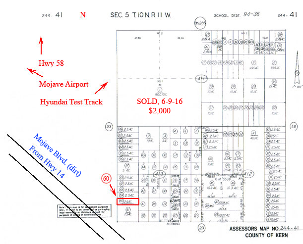
| Location- |
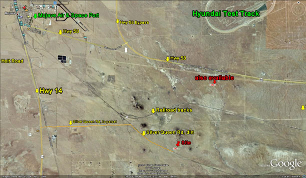
approximately 5.5 miles east of Mojave; then 2.75 miles south of Hwy 58 |
|
Area- |
Mojave | |
Acres- |
2.5 net acres | |
APN- |
244-413-60 | |
Zoning- |
esidential, vacant land (by Kern County) | |
Topography- |
level and flat | |
Dimensions- |
165’ x 660’ | |
Utilities- |
none to parcel | |
Price- |
$2,000 ($800 p/ac) | |
Existing Notes- |
free and clear | |
Terms- |
all cash | |
Remarks- |
Located
east of Mojave and its Space and Airport, and
south of Hwy 58. Subject
parcel is flat and level, but at this time does not have utilities. Parcel
sits on the western section line of section 5. Section lines often become
future roads or streets. From Hwy 14, Silver Queen Rd leads east and then
SE to with 660 feet of property. As stated earlier, Mojave Airport is THE manufacturing leader of spacecraft that will commercialize space travel. Scaled Composites of Mojave has already built and flown into sub-orbital space with its well-publicized SpaceShipOne. Scaled Composites is now testing SpaceShipTwo which will transport 6 paying passengers to experience space travel. Big money is involved in this venture. Northrop Grumman now owns Scaled Composites and Virgin Atlantic, the airlines owned by billionaire Richard Branson, has signed on as a joint venture partner. Mojave, besides it bright future in development of aerospace aircraft, is also a major transportation hub as trucking, rail, and aircraft all converge in Mojave for the distribution of goods for the western United States. The area west of Mojave, but SE of Tehachapi, is becoming a hi-tech wind farm location with millions of dollars being invested by one the world leaders in renewable wind energy, EnXco. Buyer to verify the location and access costs of all utilities. |
|
Safety and Cautions- |
Anyone inspecting, or walking on the property, off the road, should be aware that rattlesnakes and other desert wild life could be in the area. Be careful and use common sense! | |
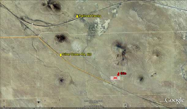
Directions to Property- |
From Palmdale or Lancaster, proceed north on the Fwy 14. Proceed past Rosamond and continue north towards Mojave. As you approach Mojave, turn right (east) on Purdy Ave. Go east on Purdy for 1 mile where it bends south and becomes United St. Go south on United St for 2 miles. Dirt road is Silver Queen but has no street sign. Go east on Silver Queen Rd for 2.5 miles. Then continue to follow the dirt road as it bends to the SE that has the utility poles. Follow this road for 2 miles. Stop. You are at the east border of section 5. Dirt road that goes due north is 33rd St. If you look due north, up 33rd St, you should see a group of buttes about 1/2 mile away. Proceed north on 33rd St for 495 feet. Stop. You are at the SW corner of parcel 60. | |